Our Monitoring Solutions for Securing Infrastructure Projects

The Lynnwood Link Extension L300 is now officially open, to greatly improve commute with 13.7 km light rail and 4 new stations in the Seattle area. 🎉🚊

In 2020, Sixense Northern America joined forces with our client Skanska to ensure the safety and success of this highly anticipated project. Throughout the construction process of the city lightrail extension, we provided cutting-edge automated monitoring solutions for soldier pile and wall stability.

With our Automatic Motorised Total Stations – Cyclops technology, we monitored 12 soldier pile and wall locations for nearly 19 months to guarantee smooth operations. 🏗️ Our Geoscope IDMS web-based data server also made it easy to collect and manage all the monitoring data, helping the project stay on schedule.

Now, thanks to the hard work of all involved, riders can enjoy a faster, more reliable transit service in the area. Check out the photos below to see how Sixense contributed to this incredible transformative project.

Revisiting Our Impact in Tunneling and Geotechnical Monitoring

[Tunnelling under Highway] – Continuous ground and surface monitoring in Canada

Sixense Northern America provided the monitoring for the recently completed Watermain Replacement project (located in the City of Brampton and City of Mississauga), in Ontario, near Toronto. 🚧

Tunnelling was required below Highway 407 and Heritage Road, demanding precise monitoring solutions to limit ground movements, ensure safety, and guarantee efficiency throughout the process.

Here’s how Sixense contributed:

📡 Installed one AMTS to monitor highway surfaces using reflectorless points.
📏 Positioned two tiltmeters on the bridge abutment to monitor structural movements.
🛠️ Implemented reflectorless points in three remote arrays, surpassing traditional survey methods.

It was a pleasure to ensure this project proceeded smoothly & safely with the trust of our client! Sixense’s innovative approach not only provided the required accuracy with a higher frequency of readings but also minimised disruption by eliminating the need for lane closures during the installation, survey, and decommissioning phases. 👏

Revisiting Our Digital Transformation Journey in Infrastructure

The teams at Sixense Romania are renowned for their expertise in infrastructure inspection and monitoring. As part of their digital transition, they called on Beyond Insite to optimize their processes and improve the efficiency of their interventions.

Several projects have been inspected such as retail, office, and residential buildings, for example the Auchan hypermarkets in Romania, as well as infrastructure such as the maritime dikes of Port Constanta and multiple other projects. They already benefit from the Beyond InSite MyCheck module.

🚧 MyCheck: a revolution in inspections

Thanks to the MyCheck application, Sixense Romania has taken a major step forward:

-Defect localization with photo on plan
-Standardization of inspections: same procedure for all incident reports
-Automatic report generation
-Precise statistics for improved analysis

Some key figures:

+22,000 inspections reported via the application.

+70 inspection sites, including supermarkets, hotels, and offices.

These advances allow Sixense Romania to guarantee quality interventions and exemplary responsiveness.

Maintenance Strategies: Improve Asset Performance

🚧 Maintenance strategies are critical to ensuring the longevity and safety of infrastructure assets across multiple industries. Ranging from corrective to proactive, these strategies play a critical role in extending asset lifespan, optimizing performance, and mitigating the risk of downtime and failure.

🔃 Understanding the asset lifecycle is critical to developing effective maintenance strategies. It includes stages such as installation, operation, degradation, intervention, repair, and eventual decommissioning. Metrics such as Time to Maintenance (TTM), Time to Failure (TTF), and Time to Repair (TTR) indicate asset performance and maintenance effectiveness.

Different Maintenance Strategies ⬇️
-Corrective maintenance: addresses issues as they occur, suitable for unexpected failures with limited resources.
-Preventive maintenance: includes scheduled inspections and maintenance tasks to prevent potential failures, ideal for assets with predictable degradation patterns.
-Condition-based maintenance: uses real-time data and condition monitoring technologies to trigger maintenance, ideal for assets with variable usage patterns.
-Predictive maintenance: predicts failures using advanced analytics and historical data, ideal for assets with well-understood failure modes.

Sulejówek Road Tunnel

🗺 📍 Sixense Polska has been entrusted with a second tunnel monitoring project in Sulejówek. The project consists of the construction of a two-lane road tunnel, a footpath, and a path under the Warsaw-Terespol railway line. The collision-free crossing is expected to reduce traffic congestion on the Warsaw ring road. 🛣 🚧

🔎 Our monitoring is crucial for rail traffic safety. The system is set up to automatically send notifications to stakeholders when set thresholds are exceeded. Measurements are made available immediately, allowing the situation to be monitored in real time. The automated system eliminates human error and is virtually maintenance free, increasing its reliability.

✅ During the work, our Cyclops system continuously monitors the stability and displacement of the tracks in all three axes: x, y and z. Monitoring is particularly important because the tracks are not out of service during the work and trains run without interruption, excluding occasional night work.

💬 “This is my first project after joining the team, which I have led from the very beginning, and I am grateful for the trust placed in me. All parties involved in the investment process care about smooth communication, so I am even more satisfied with the cooperation” – emphasizes Paula Piela, Project Manager at Sixense Polska.

The project is financed by the National Reconstruction Plan and implemented in cooperation with the Minsk District and the City of Sulejówek. The project investor is PKP PLK and the contractor is INTOP Warszawa Sp. z o.o. The investment is scheduled for completion in the 2nd quarter of 2025.

🤝 We would like to thank everyone for their participation and cooperation in this project. We are convinced that our activities will contribute to increased safety and more efficient communication between the parties involved.

Automatic Monitoring During Road Construction Works in Ontario

We’re thrilled to announce that Sixense Northern America is providing automated monitoring on the Highway 400 widening at the Town of Innisfil, as a testament to our unwavering commitment to public safety. 🚧

🔎 Our comprehensive monitoring solutions are deployed while newly constructed 1.9-meter ID culverts are installed and tunneling is conducted (just three meters under the highway surface):

✅ 4 Automatic Motorised Total Stations (AMTS) installed in 2 phases – Powered by solar panels and backup batteries, the devices are self-sufficient, ensuring continuous monitoring without interruption,

✅ 80 Surface Monitoring Points (SMP) – Deployed remotely in multiple arrays, these reflectorless points eliminate the need for highway lane closures during installation, survey, or decommissioning while maintaining high accuracy and frequency of readings,

✅ 18 In-Ground Monitoring Points (IMP) – Strategically installed at a depth of 1.5 m in the slopes, these rods facilitate quicker responses to construction activities and prevent delays, even in frozen ground conditions,

✅ 10 Building Monitoring Points – Ensuring structural stability on the Reive Blvd Bridge over Innisfil Creek and adjacent launch shaft, these points are integral in maintaining safety standards.

Manage Your Signs in your Local Authority

🚦 Are you looking to optimise the management of horizontal signs (pedestrian crossings, road markings, etc.) and vertical signs (road signs, traffic lights, etc.) while centralising the operational activities involved in monitoring them to facilitate decision-making?

We have the solution for you: Beyond Asset can help you maintain and monitor your city’s signs.

🗺️ Visualise your entire sign database (horizontal and vertical signs) on a map easily to find:

Complete data on road markings and vertical equipment,
A detailed description of the intervention zones,
The precise geographical position of each item,
Filter inspections by type of work and area of activity,
Photos and history of interventions.
📅 Plan and organise maintenance operations and interventions, while ensuring accurate budget monitoring, according to the specific characteristics of each area.

With the mobile version of Beyond Asset, operators in the field can report information in real time, even in offline mode, and synchronise data after the operation.

✅ Integrate decision-making processes into the solution to propose corrective actions that will optimise your signs management.

Building on Strong Foundations

In the heart of our divisions, Sixense Geophysics reveals the subsoil beneath your projects with advanced 3D imaging solutions. This helps you manage risks and ensure your projects progress smoothly and safely.

From cavity and water leakage detection to geological modelling and diagnosis of earthwork, our expertise covers a wide range of market segments:


🚆  Transport Infrastructures: roads, rails, metros and tunnels, waterways, ports and airports.

🏯 Heritage, Cities, and Regions: buildings, structures, foundations and excavations, urban development and natural hazards.

⚡️ Energy and Industry: dams and water management, oil and gas, electricity (nuclear, wind, and transmission grids), mining, quarrying, industries, and processes.


With over 25 years of experience, we leverage conventional and patented geophysical methods to provide solutions tailored to your needs.


At Sixense, we take pride in ensuring the success of your projects from every angle with our versatile and experienced teams.

From Sky to Data: Helimap’s High-Precision Mapping Solutions

Introducing Helimap, a member of the Sixense group revolutionizing LiDAR as well as photogrammetric data acquisition and processing services in Switzerland and beyond.


Using helicopters, drones, ultralights, or terrestrial vehicles, Helimap captures and processes your data, ensuring unparalleled precision and flexibility. With high flexibility, rapid deployment, and unlimited modularity, they can map terrains from all angles with high precision.  


Key Areas of Expertise:  

  • Corridor Mapping 
  • Oblique Mapping of Complex and Inaccessible Areas 
  • Mapping of Small and Medium Areas 
  • High Precision/Resolution
  • Thermal/NIR/Oblique/Panoramic Imaging 


Contact us today to discover the full spectrum of services Sixense Group can offer to your projects. 

Method Cyljet

Discover Cyljet, our exclusive solution dedicated to Jet Grouting works.
Jet Grouting works involve injecting a high-energy kinetic jet of cement grout to from columns of soil-cement mix. To optimize these works, our team of geophysicists has developed a non-destructive method named Cyljet.


🔎Jet Grouting works involve injecting a high-energy kinetic jet of cement grout to form columns of soil-cement mix. To optimize these works, our team of geophysicists has developed a non-destructive method named Cyljet. 


This patented geophysical solution addresses three challenges:
➡ Quickly control the dimension of the columns (within 24 hours)
➡ Use only the strictly necessary quantities of materials
➡Optimize the costs and schedule of your construction sites


👉How does Cyljet work?
Cyljet allows in-situ control of the column dimensions following their construction. The solution is based on the Electric Cylinder® method, which enables a 3D electrical investigation around the column. A measuring cable is installed at the core of the column and records the potential differences generated by an induced electric current. The processing and modeling of the recorded data in the columns allow establishing the shape of the constructed column.


➕ Cyljet is a unique method that eliminates the need for coring.

It has been used by our geophysics experts in France, particularly for the renovation of the RER C, the Grand Paris metro works. It has been used as well as on numerous international construction sites like soil consolidation projects such as at Lake Nyos in Cameroon, tunnel or metro projects in New York and San Francisco in the United States, Vancouver in Canada, and Melbourne in Australia.

Translating Success: Sixense’s Expertise in Metro Construction

Construction work on Porto’s seventh metro line began in 2021. Commissioning is scheduled for late 2024.  🚧 🚉


The new line comprises a 3 km-long tunnel built using traditional methods and 4 underground stations. It passes through Porto’s historic city center, requiring continuous monitoring to keep the impact of the work under control. The monitoring contract was awarded to Sixense by the Ferrovial / ACA consortium in 2021 for 30 months.


✅ Since the start of the underground work, Sixense has set up a monitoring system to follow the impact of the work: tunnelling and underground stations construction in a dense urban environment with many old and sensitive buildings.


🔎 Our monitoring system comprises:

– 45 Cyclops, an automatic topography system along the entire line, with over 2,000 measurement points
– More than 350 geotechnical, structural and hydrological sensors: piezometers, inclinometers, crackmeters, etc.


Our instruments monitor ground and building movements, with data available at any time on our monitoring platform. Automatic alarms are also sent when predefined thresholds are exceeded, helping project engineers in decision making.

Bending the River

Check out this remarkable execution with our Beyond Monitoring tool in Los Angeles!


“Bending the River” is an infrastructural artwork showcasing water’s social impact.

Sixense Northern America ensured project success with our displacement monitoring program. Solar-powered Automatic Total Stations provided continuous monitoring data through Beyond Monitoring, ensuring near-real-time insights.


[Monitoring project – USA] – Real-time monitoring during trenchless tunnelling in Los Angeles


Bending the River is an infrastructural artwork that utilizes Los Angeles’s first water commons and demonstrates how the currency of water can create social capital and serve social needs. A percentage of water will be redirected through a diversion vitrified clay pipe running under the railway tracks to Metabolic Studio where the water will be lifted into a treatment wetland comprised of native plants. The regenerated water will then be distributed to a network of public parks.


Sixense Northern America was hired to carry out the displacement monitoring program that controls the potential impact of the trenchless operations on the ground, in adjacent structures, and Metrolink’s rail tracks. Two solar-powered Automatic Total Stations (ATS) were installed to continuously monitor arrays of reflectors (prisms) installed along the alignment of the 1 m diameter and 49-meter-long tunnel. The monitoring data was delivered in near-real-time through our web platform Beyond Monitoring, including automatic alerts triggered if any of the threshold values were exceeded.

Oppio method

[Wind Power] – Helping you optimize the locations of wind turbines according to acoustic and spatial constraints.


This solution is based on the simultaneous optimization of operating modes and positions of wind turbines, in order to limit the loss of electricity production while taking regulatory constraints into account.


👉 How does our Oppio method work?
In the upstream phase, for wind farm developers, we model the project taking into account various data: the location of wind turbines as well as their acoustic and electrical power characteristics.
The aim of the method is to find the optimum layout to minimize production losses, while taking account of regulatory acoustic constraints🔊


Numerical simulations are carried out to compare with the acoustic baseline (initial noise before the wind turbines are installed) and enable the calculation of a curtailment plan of the wind farm.


The Oppio method is an algorithm that seeks to optimize several factors: the wind farm’s operating modes and the position of the machines. For projects where acoustic losses are initially high, Oppio can save up to 3% in night-time productivity and 1% in cumulative day/night productivity.


With Oppio we help you:
✅ Search for optimum operating modes of the wind farm in compliance with acoustic regulations

✅ Find the optimum wind turbine locations using our algorithm.

Beltway Project

[Award Winning Project – USA] – Continuous monitoring during highway improvement works in Virginia


The Transform 66 Outside of the Beltway Project was recently named the Best Road, Bridge, or Tunnel Project at the 2023 P3 Awards. 🏆


Sixense Northern America played an important role in this massive undertaking, which aimed to revitalise Northern Virginia’s Interstate 66. 🛣 Our experts designed a monitoring system that measured the track movement, highway settlement, and movement on various other structures during drilling shaft activities, utility installations, and retaining wall construction. 🚧


🔎 The teams implemented instrumentation on twenty different sites along the project, all with distinctive challenges that required innovative ideas on installation. For example, we utilised solar panels on the systems since continuous power was unavailable. Additionally, our automated monitoring system delivered measurements 24/7 that were critical in identifying different movements and displacements that allowed mitigation plans to be executed quickly.


It’s an honor to be a part of projects that are acknowledged for their achievements and improve the lives of many. Transform 66 promises to reduce traffic congestion, improve safety, and provide commuters with more predictable travel times. Big kudos to all the other stakeholders who worked tirelessly to make it happen! 🤝

Introducing UPUS® for Effortless Structural Evaluation

At Sixense, we are dedicated to innovation. Our solution, UPUS®, accurately measures loads and stresses in cable-stayed and prestressed structures.

Key features:


Verification of the Structural Reinforcement: UPUS® verifies the acceptance of structural reinforcement or assembly brought by prestressing bars to limit critical structural hazards.


Remarkable Accuracy: With UPUS®, we can achieve a measurement accuracy 10 times better than traditional methods.


🌍Why UPUS?

UPUS® operates without heavy equipment, making the process more efficient and cost-effective. It not only provides real-time stress and strain measurements but also detects hidden defects, such as age-related corrosion and other failures, before they become visible. This proactive approach empowers engineers and managers to take preventive actions.


Choose UPUS® by Sixense for precision, efficiency, and unparalleled structural insight powered by our longstanding passion for innovation.

Pika

Pika: the geological monitoring solution for mines, tunnels & natural heritage

Why digitalise geological monitoring?

👉 To optimise your worksite’s operational performance and reduce costs!

With this in mind, Sixense has developed Pika, a solution which allows you to:

✔ Have a photogrammetric solution for accurate, fast 2D and 3D reconstruction to make the right decisions on the worksite

✔ Master geological data to easily manage, share, centralise and archive project data through a collaborative Web interface
✔ Exhaustively monitor geological features over time
✔ Have specific tools to the world of geology to conduct analyses
✔ Have a safe and fast alternative to manual surveys to limit human intervention in high-risk areas
✔ Harmonise working methods between the different actors to standardise methods and know-how

Sissterra®

Make the subsurface visible and control risks through 3D imaging.

We have developed an applied #geophysics solution related to civil engineering issues in order to limit the risks associated with the subsoil called Sissterra®.

This internal turnkey passive seismic solution helps to:
– Consolidate the geological model and controlling associated risks.
– Optimize underground work progress: anticipation and adjustment of construction methods.
– Optimize the costs of soil improvement work: delimitation of the areas to be treated and treatments evaluations.

How does Sissterra® work?
Thanks to a network of so-called “autonomous” sensors (wireless and operating by battery), deployed by our technicians / engineers, we record ambient vibrations produced by anthropogenic activity (seismic background noise), especially in constrained environments such as industrial zones, city centers or over old quarries.

These sensors are easily and rapidly deployed due to their design. They record the ambient vibrations to allow a detailed analysis of the content in terms of seismic wave. The large volume of data goes through a complex data processing and thus makes it possible to deliver a 3D imagery of the subsoil to the clients and accompany them in interpretation.

To date, Sissterra® has been deployed on various projects:
– Optimization of underground tunnel boring works (Grand Paris Express)
– Subsurface Risk Management in Constrained Industrial Environments
– Seismic hazard management and assistance in defining the foundation system for the installation of sensitive buildings.

Build’ Health

Follow-up of structures state of health by vibration monitoring

Sixense’s Build’Health solution has been developed to meet the needs of builders, owners and managers of buildings:

– Monitor the health of buildings throughout their lifespan
– Quickly estimate the level of damage suffered by buildings after an event (works, accident, earthquake)
– Optimize risk management during urban construction projects

Build’Health adapts to your needs:

Our solution can be used on a manual basis, for example annually.
For the most sensitive structures, Build’Health works automatically and continuously with an alarm triggered in case of building degradation. Indeed, a few minutes per building are enough and the comparison of successive measurements allows to detect any damage.

The benefits of Build’Health:

– Simple, global, non-destructive and non-intrusive method
– Reliable mathematical indicator of the overall health of a structure, independently from visual analysis
– Determination of strategic information for the management of a property portfolio, building insurance or real estate investments
– Help in the analysis of the conditions of safe access to a structure after an accident, a fire or an earthquake
– Assistance in preventive measures and analysis of the impact of works

4DBloc

Introducing 4DBloc – a GNSS-based deformation monitoring sensor, providing real-time monitoring of ground surfaces and built structures.

A simple and economical deformation monitoring system:

4DBloc is a small, rugged, single-frequency GNSS receiver designed to be deployed on the field with multiple devices connected to a network.

It is a robust system with a small footprint and low power consumption, that requires no regular maintenance.

How does 4DBloc work?

The principle is to keep one 4DBloc fixed in its coordinates at a known and stable location (known as base station) while other 4DBloc are installed in the monitoring zone.

Fully automated and connected to our Beyond Monitoring web platform, the 4DBloc network records and transmits in real-time its 3D coordinates providing information on the structure, surfaces, or sub-surface deformation.

4DBloc applications include:

– Transport infrastructure: bridges, rails, roads, etc.
– Hydraulic infrastructure: dams, dykes, harbours, etc.
– Landslides
– Reclamation works, mines etc.

4DShape – 3D continuous linear inclinometer

4DShape – 3D continuous linear inclinometer

A compact and adaptable monitoring solution:

4DShape is composed of a flexible chain of high precision 3D inclinometers with integration of deformations. It is a solution allowing monitoring of millimetric movements continually and automatically in soils and on structures.

4DShape offers:

– a compact monitoring solution to observe in real-time 3D deformation of soil and structures
– reliable and precise measurements to understand structural behaviour

4DShape has many different applications:

– Automated measurements of boreholes (automatic vertical profiles)
– Convergence measurements of tunnels and galleries
– Settlement measurements along horizontal profiles (embankments, rail tracks, etc.)
– Deformation measurements of vertical structures (walls, columns, etc.)

Benefits and added value of 4DShape:

– Our 4DShape is a versatile and compact instrument solution that can be adapted to your project’s specific requirements: measurements for buildings, linear infrastructures, and subsoil projects.
– 4DShape is very well suited to long-term monitoring.
– It can be associated with an automatic alarm system when used with our Beyond Monitoring platform.

Investing in our Employees and Quality

Our success depends on the quality of our services and the expertise of our employees. That’s why we invest in both, providing our clients with the best possible solutions and our associates with the tools and support they need to excel in their work.

Installing sensors and taking measurements on structures are often difficult, create challenging conditions, and can be physically demanding and hazardous for our teams. Our priority has always been to prevent risks such as accidents, long-term physical strain, and inaccuracy.

Therefore, Sixense Group have been investing in well-being and expertise by using exoskeletons that help support our team onsite. These devices are lightweight (2kg), easily adjustable to all operators and tasks, and reduce the strain from work.

By reducing levels of risk, we can ensure that our employees are safe and able to perform their best and deliver the highest quality for our clients.

At Sixense, our commitment to expertise, our conception of employees’ well-being, and our concern for quality set us apart. We look forward to continuing to grow and innovate in this area!

Sixense ensures successful completion of tunnel excavation of Highway 401&409 Rail-Tunnels Project – Canada

A major tunnel upgrade and excavation project

The existing Kitchener Corridor with three (3) live rails are in the City of Toronto, Ontario, next to Toronto Pearson International Airport. To bring more frequent service to GO Transit customers, Metrolinx and Infrastructure Ontario started a twin tunnel construction in 2018. This infrastructure upgrade is taking place less than three metres underneath Highways 401 and 409 – all without disrupting the continuous traffic flow above.


Sixense provided a tailor-made monitoring solution in a challenging environment

Sixense was chosen by Toronto Tunnel Partners (TTP), a joint venture between STRABAG Inc. and EllisDon Civil Ltd. to perform environmental, geotechnical and structural monitoring of the existing rail tunnel and twenty-one (21) lanes of live highway, 401 and 409, one of North America’s busiest highway corridor.

In order to achieve the required high spatial density, high frequency monitoring while minimize interruptions of existing highway traffic and manual readings in heavy traffic areas, an innovative near real-time deformation monitoring system was designed and implemented. It consists of 8 Sixense’s Centuar automatic motorized total station (AMTS) with over 450 reflector-less points on the highway and 3 AMTS in the existing rail tunnel, complemented by Shape Arrays, In-place Inclinometers, Piezometers, Tiltmeters, Vibration and Noise Monitoring.


Completion of a milestone for the project

On January 22, 2021, the project reached a big milestone by successfully finishing the second tunnel excavation. Sixense’s expertise and dedication to the continued success of the project is well recognized by the project team. The new tunnels support the GO Expansion program and will transform the Kitchener line to a more convenient two-way, all-day train service.

InSAR and Earth Observation Techniques for Infrastructure (C805)

The development of Earth Observation techniques

Earth Observation covers a wide range of technologies that have come of age throughout the past two decades and are expanding into a new era of cloud processing, very high-resolution and near real-time service delivery with the use of spaceborne data within infrastructure asset management.

The launch of the new CIRIA guidance report

We are delighted to announce that the new CIRIA (Construction Industry Research and Information Association) guidelines on Earth Observation and InSAR technology in civil infrastructure is now available.

Produced by a consortium led by Sixense and Imperial College London, the guidance report improves accessibility to Earth Observation technology by understanding techniques and products applied to infrastructure management.

What you will learn about ?

The report draws on the extensive experience of the consortium members and detail current practices, illustrated with case study examples, and outline respective advantages and limitations of the various techniques to assist all users and in particular those involved in asset management and construction. It forms an important step towards establishing the use of Earth Observation techniques as a matter of ongoing best practice for asset management in civil infrastructure projects.

Follow the link below to order your copy:

https://www.ciria.org/ItemDetail?iProductCode=C805&Category=BOOK&WebsiteKey=3f18c87a-d62b-4eca-8ef4-9b09309c1c91

For more information, please contact satellite@sixense-group.com

The Geoscope / Beyond Monitoring platform at the ANDRA site in Bure

The Geoscope database, installed for the Data Acquisition and Management System (SAGD) of the ANDRA underground research laboratory of Bure (France), celebrates its 20th anniversary this summer.

The Geoscope database was created on Thursday June 13, 2002
The first acquisition point PPA0005_DFO_01 was created on June 26, 2002.

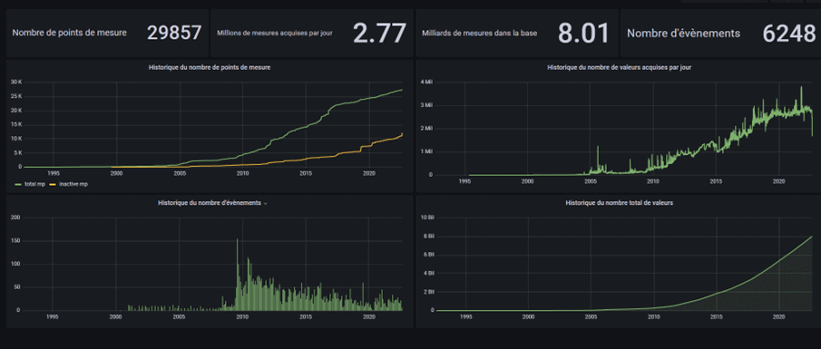
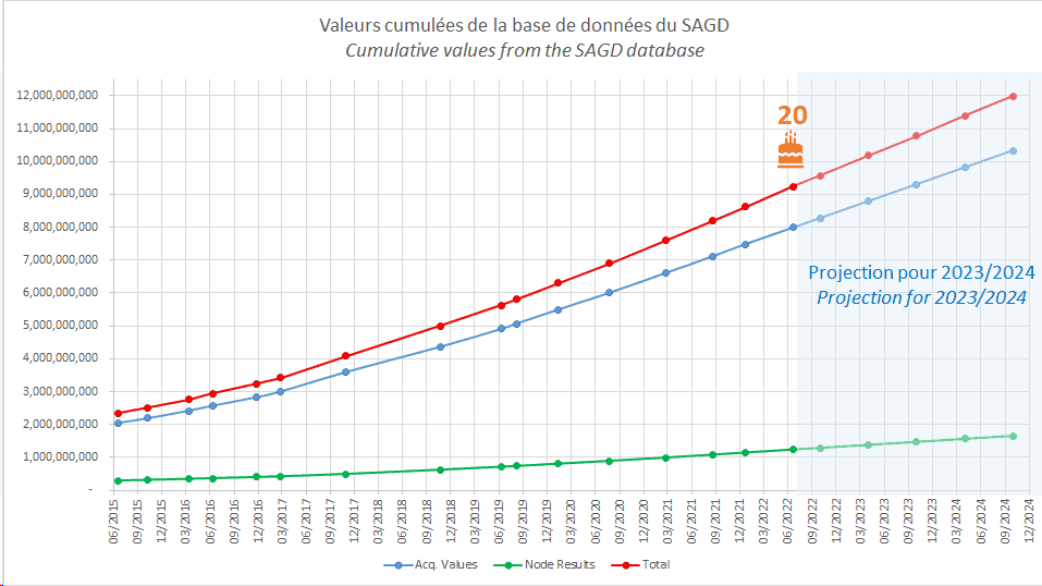
Today this database is still working and holds the world record of the largest Geoscope database with 9 billion values (9 228 800 000 values on the 20th anniversary).
The number of sensors is 30 000, and the database size is 1.34 Tb.

Geoscope / Beyond Monitoring is Sixense platform for management of monitoring data. Continuously developed and improved since 1997, it is used successfully on monitoring sites worldwide, from mega projects to small 10 sensors locations.

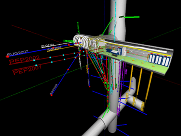
ANDRA is the French National Agency for Radioactive Waste Management. The Bure laboratory is a network of horizontal underground galleries dug at a vertical depth of 500 m beneath the surface. It is used to evaluate the containment properties of the geological formation, in view of a potential future nuclear waste storage (CIGEO project).

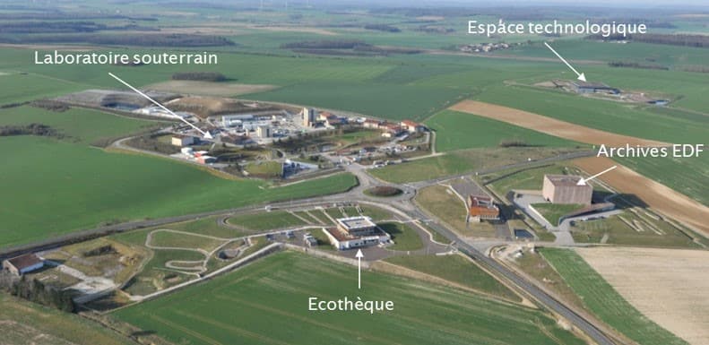
The ANDRA Meuse/Haute-Marne research center in Bure (55)

The Bure Laboratory, or the Meuse/Haute-Marne Underground Research Laboratory, is a network of underground galleries located 500 m deep under the territory of the municipalities of Bure (Meuse) and Saudron (Haute-Marne) in France.

As part of research on the storage of radioactive waste in deep geological layers, this underground research laboratory is operated by the National Agency for Radioactive Waste Management (ANDRA) in order to assess the confinement properties of the geological formation located at a depth of 500 meters, in view of a potential future CIGEO nuclear waste storage project.
On the surface, a network of piezometric drillings and environmental monitoring stations record natural parameters.

The ANDRA site in Bure

Data Acquisition and Management System

The Underground Research Laboratory hosts several dozen types of mechanical, thermal, chemical, hydraulic, short and long term experiments, carried out by researchers from the laboratory but also various external French and foreign laboratories, and private companies selected through specific calls for tenders.
The measurements are therefore of all types, all frequencies, all formats.

Aware of the crucial nature of measured data, ANDRA issued a call for tenders in 1999 to design an instrumentation and monitoring database (which would today be called an instrumentation and monitoring platform), with the following priorities:

• Data security requirement, among the thousands of measurements carried out in the laboratory, none must ever be lost or modified, all the raw measurements must be kept and protected without any modification.
• Consequently, computer security requirement, secure and differentiated access, by research entity, by experimentation, by sensor.
• Requirement for processing power and ease of use and ergonomics, to help researchers extract the maximum information from the measured data.
• Requirement of durability over time, of permanent evolution to follow and survive changes in computer hardware.

Sixense Monitoring (then called Soldata) offered its existing Geoscope solution. Geoscope is the monitoring platform used by Sixense teams around the world for their own instrumentation and monitoring services. ANDRA’s requirements are guaranteed, among other things, by the fact that our teams have the same needs every day.

Data visualisation of the gallery -445 m with Geoscope 6

In 2022, in the continuity of the permanent evolution of its solution, Sixense launches the Beyond Monitoring platform, direct successor to Geoscope:

https://www.sixense-group.com/en/offer/monitoring/soil-structural-and-environmental-measurement/geoscope-beyond-monitoring

Geoscope database statistics (June 2022)

Database size: 1.34 TB
Size of a full database backup, after compression: 120 GB

Number of measurement points: 29,190

Number of values ​​measured: 7,990,623,000
Number of values ​​calculated: 1,238,177,000
Number of alarms: 2,627,587
Number of daily summary values: 53,038,329
Number of hourly summary values: 1,125,941,000

Information on the data flow managed by the SAGD database with Geoscope at 08/2022
Evolution of the database size since 2015

Monitoring of the structural health of the 1915Çanakkale bridge

Monitoring of the structural health of the largest suspension bridge in the world in Turkey

An exceptional structure

Sixense’s Monitoring division works on an extraordinary structure in the Dardanelles Strait: the 1915Çanakkale bridge, which the Turks call the “1915 Dardanelles bridge”, in reference to a naval victory for Turkey. This suspension bridge has the longest central span in the world: 2,023 meters, in homage to the centenary of the foundation of the Turkish Republic.

What are the particularities of this structure?

In Turkey, 400 km southwest of Istanbul, the Dardanelles Strait is the only access between the Black Sea and the Mediterranean Sea. It is there, near the city of Çanakkale (former city of Troy), that the 1915 Çanakkale bridge stands and was inaugurated at the end of March 2022.

This 3,563-meter-long suspension bridge is made up of two pylons 2,023 meters apart supporting a 45-meter-wide deck, through 2 cables and its suspension.

The structure was built by a consortium of 2 Turkish companies (Limak and Yapı Merkezi) and 2 South Korean companies (DL E&C and SK ecoplant). Sixense has been selected by this consortium to design, manufacture and install an exceptional instrumentation system with more than 1,000 sensors… a world premiere!

How will the Sixense SHM system help optimize bridge operations?

These 1,000 sensors will provide a continuous view of the multiple behaviours of the structure in relation to stresses to which it will be subjected. The system will provide information on deck and cable vibrations, stress concentrations in the mechanical elements, temperature at various points on the structure, weather and seismic information, and the concentration of traffic on the structure.

The data is accessible in real time on the Sixense monitoring platform.

Much more than a visualization of phenomena, the system put in place by Sixense will allow scenario predictions by varying the environmental parameters of the structure. Thus, the operator will be able to estimate the aging of the structure according to its traffic increase predictions.

How we can build more resilient infrastructure projects?

A sustainable infrastructure also means a more resilient one. For that matter, we asked Bunafsha Mislimshoeva, Head of International Projects Development at Resallience (our design office specialised in climate resilience), to explain more about this concept and how we can build more resilient transport infrastructure projects, in the context of an everchanging climate environment.

Let’s see what our expert Bunafsha has to say about this. ?

? Could you please explain to us the importance of building a more resilient infrastructure? Please provide us with a bit of context: where does this urgency come from and why now?

? What does building climate resilience actually mean?  

? How do you see the degree of preparation of other countries regarding the subject of climate resilience? Is Europe ready to act or has it already started planning?

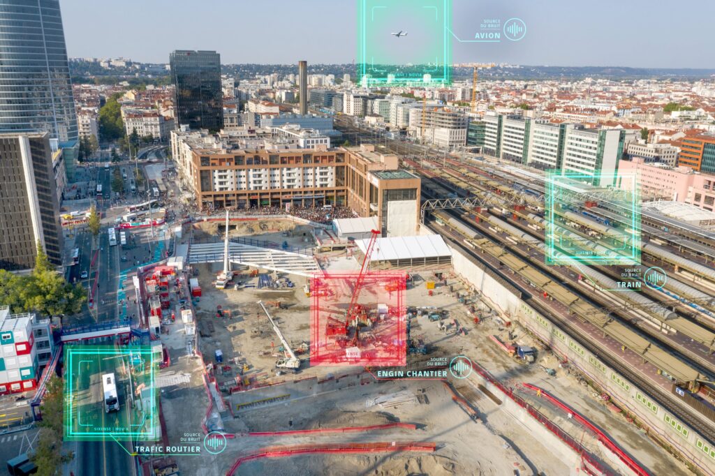
Nora: Automatic identification solution of acoustic events originating from your worksite

Thanks to artificial intelligence, Sixense has developed the Novia solution to answer one of the major questions on your worksites: “Is the excessive noise level caused by my on-site work or not?”. This solution, based on the machine learning technology, allows to identify whether or not a particular sound emanates from your construction noises or the surrounding urban activity.

Accessible via our Geoscope interface, Nora allows you to reduce the risks of complaints, site stoppages or even penalties. The Novia function can be activated at any time on all standard monitoring systems and automatically adapted at each phase of the construction.

This gives you a clear and transparent mean to justify a good noise management on your worksite to your clients and authorities.

If you are facing noise issues on your worksite in a sensitive urban environment, get in touch with our expert Karim Benaguid for more information.

Discover our solution in detail here.


Resallience, awarded by the French Committee of the World Road Association (PIARC)

Resallience, our design office specialized in climate resilience, won the PIARC France 2021 Award in the resilience category.

Resilience of road infrastructures to face climate change

The French Committee of the World Road Association has launched the PIARC France 2021 Awards to highlight the road and transport sector. Our Resallience teams: Philippe Sohouenou, Didier Soto, Camille Vignote and Karim Selouane, wrote a paper that won them first place ex-aequo, in the Resilience category for the Calgary congress. This is a real international recognition of their work on the technical, scientific and innovation aspect.


The paper entitled “A framework to prioritize critical road segments for climate-resilience investments” was presented by Philippe Sohouenou at the XVI World Congress on Winter Roads and Road Resilience held virtually. He spoke at the “Road Network Resilience to Climate Change” session on February 9 and at the “Poster Session 7” on February 10, 2022.


Here is an extract from the full article available below:

“With climate change, the impacts of natural hazards on road networks and mobility could worsen. Hence, strengthening the resilience of road infrastructures to natural hazards is more critical than ever before. To reach this objective, the design, operation and maintenance of road infrastructures should be informed by climate, transport, infrastructure and land-use data and models. In particular, transport operators and public authorities need to analyze such data and models to identify critical roads, which should be given priority for resilience strengthening investments. “

Mont Blanc: LiDAR survey of Europe’s highest peak

Sixense Mapping carried out a high density (1000 points/m²) helicopter-borne LiDAR measurement of the summit of Mont Blanc as part of a commercial scientific mission. This measurement, which took place two weeks before the “official” biennial measurement by the French chartered surveyors’ association, is the subject of a detailed article in the December 2021 issue of XYZ, the journal of the Association Francophone de Topographie (French-speaking association of topography).


The use of LiDAR for such a measurement is a first, Mathieu Peyrega, development engineer at Sixense Mapping, explains:


“This alternative method to mountaineering expeditions and conventional topographic techniques allows for a measurement of equivalent accuracy. The result, to our knowledge, is the highest density source of information ever produced on the roof of Western Europe, with an accuracy level fully equivalent to traditional survey techniques.”


In addition to the experimental validation of potentially being able to use our sensors in these extreme conditions, the obtained measurement accuracy (+/- 10cm@95%) is identical to the terrestrial methods and confirms the effectiveness of this technique. The short implementation time makes it possible to use it with a reactivity that is not possible with conventional approaches.


The results obtained, correlated with the weather conditions observed between the two measurements, bring a new perspective on the “short-term” movements of this emblematic peak, which has moved by nearly 13 meters in planimetry and nearly 1 meter in altimetry over the period. In a way, this leads to relativise the “absolute” interest of a centimetric precision measurement in this specific context.


However, for us, this remains an exceptional flight that illustrates the extent of our systems’ capabilities, our teams, and our ‘know-how’.

Sixense awarded monitoring contract for Pattullo Bridge replacement project – Canada

A major bridge project allowing a safer, easier, and toll-free commute

The existing Pattullo Bridge is an arch bridge that connects New Westminster and Surrey and provides on average 75,700 cars and 3840 trucks a daily option for crossing over the Fraser River in the Metro Vancouver area. At the start of 2020, Fraser Crossing Partners (a joint venture between ACCIONA and Aecon Group inc ) was selected to design and construct the replacement bridge. The improved crossing will feature four modern, wider lanes for traffic, with allowance for a potential future expansion to six lanespedestrian and cyclist access, and better connections to, from, and near the bridge. 


Multi-stakeholder project site requiring innovative and safe solutions

A light rail tunnel, two additional bridges (one light rail, one heavy rail) and the existing Pattullo Bridge, are all located within proximity of the location of the new bridge alignment. Sixense was chosen by Fraser Crossing Partners to develop a monitoring solution that will encompass the surrounding major structures and railways enabling continued safe use of the nearby infrastructure throughout the Project construction 

Through coordination and cooperation with a variety of infrastructure owners, Sixense has designed and implemented a comprehensive monitoring solution, including 13 Sixense patented Cyclops AMTS systems monitoring hundreds of prisms, 9 4D-BLOC GNSS sensors, 28 vibration monitors and 46 wireless tilt sensors.  


An ongoing partnership until the project completion

The innovative monitoring system will be actively administered and maintained by Sixense, delivering near-real-time data on the Geoscope platform to all involved stakeholders. Uninterrupted, safe operation of all surrounding infrastructure will continue to be enabled by the Sixense solution through project completion.

Load testing on the Clémenceau Bridge in Brest

Brest Metropole, in France, plans on operating a second tramway line as well as a High Level of Service Bus line (also called Busway or Trambus) in 2026. Their route includes the Clémenceau Bridge, an infrastructure built 30 years ago. However, this one has not been designed to support the weight of tramway and High Level of Service lines in addition to the road traffic. 

The contracting authority entrusted Sixense to perform the investigations and checks needed on site to refine the sizing of the reinforcement work planned on the structure, in anticipation of the new tramway crossing and the bus line. To do so, our teams carried out load testing during the night of the 25th to the 26th of February 2021.  

In order to successfully complete the operation, the traffic was stopped to make room for several loaded trucks of a total weight of 120 tons. The bridge has been equipped with targets on the beams supporting the bridge, all aimed by a theodolite which was itself connected to computers with our Geoscope software, recording in real time the least oscillation of the loaded structure.  


Nicolas Sanchez, our team leader in charge of this operation explains:  

“An infrastructure is designed for a certain traffic. It is very likely that it will need to be reinforced. It is already more or less what is expected. We have installed a prism under each 17 beams. We target each beam with a laser equipment. The aim is to see, when loaded, the infrastructure’s deformation. We immediately receive the raw results, but we will still have to process all the information in order to provide results for the Brest Metropole Organisation” 


One unique tool to assess the vulnerability of assets

Our design offices specialised in climate resilience, Resallience, assists the Deposit Fund Caisse des Dépôts (CDC) Habitat with its adaptation strategy to climate change. They joined forces with our experts in engineering of existing structures to develop the first DPR platform (Climate Resilience Performance Diagnosis).

It is a decision support system composed of, on one hand, a hypervisor, powered by a geographical information system, and on the other hand, an analytical spreadsheet. The DPR allows to assess the criticality level of built heritage to climate risks. It also analyses the technical and financial risks of impact of these contingencies on the components, the subsystems and the systems of the groups of buildings. The DPR applies to all the property assets of CDC Habitat, close to 500 000 housings, and will allow to power the pluri-annual plans of investments to restore this heritage, to adapt the design of the new constructions and this way, better adapt to climate change on the horizon of 2050.

This project comes within the scope of a partnership between CDC Habitat, the FFA Insurance (French Federation of Insurances and the association of natural risks mission – MNR) created in 2000 by insurers in order to contribute to a better knowledge of natural risks.


Discover the article from CDC Habitat for more information.

Structural monitoring of the Normandy Bridge

The Normandy Bridge, a major structure that stands up to the elements

Since 1995, the Normandy Bridge is crossing the Seine estuary and connects Le Havre and Honfleur by a 2,141-meter long prestressed concrete and steel structure. It has a cable-stayed span of 856 meters. The deck of the structure accommodates 4 vehicular traffic lanes as well as bicycle and pedestrian paths. Its 184 stays, with up to 53 strands for the largest cables, ensure that the central steel deck is maintained for no less than 654 m above the navigation channel.

The durability of this structure, a symbol of French know-how in terms of Civil Engineering but subject to the winds and tides at the Seine estuary, is ensured by regular and rigorous maintenance. This maintenace is backed by the monitoring of the structure with a set of specific sensors but also by the periodic control of the structure’s and particularily the ageing of the stay cables


Increased surveillance of the structure to ensure its durability

Between 2011 and 2018, Sixense installed and maintained a monitoring system composed of about a hundred sensors: displacement, inclination, force in the stay cables, temperature, vibration of the structure, weather station and even breakage of stay cable wires. This system, which measures both the external stresses and the structural responses of the structure, enables a better understanding of the structure and anticipation of maintenance operations.

Since 2011, Sixense has also carried out periodic testing of the stay cables to determine their level of aging and check their residual structural strength. The Uscan process, patented jointly with the Gustave Eiffel University, works on the principle of ultrasonic guided waves to check the health of the strand wires in the areas where the stay wires are anchored.


Thanks to these continuous and periodic measurements on the sensitive componentss of the structure, the CCISE* can anticipate and schedule maintenance operations that will keep this masterpiece of French Civil Engineering intact for many years to come.


CCISE*: Seine-Estuaire Chamber of Commerce and Industry


Our SHM experts working on the Normandy bridge

Environmental monitoring, modelling and assessment works on High Speed 2, Europe’s largest railway infrastructure project

A major high-speed railway project across the UK

High Speed 2 (HS2) Phase 1 is a large high-speed railway project in the United Kingdom which will link London and Birmingham, with a future second phase to reach Manchester and Leeds in Northern England.

This major project will provide increased capacity and reliability of the railway links and should help manage the rising number of passengers.

HS2 phase 1 is expected to open to passengers in 2026 and Phase 2 around 2033.


Sixense expertise applied to this environmentally challenging major project

Sixense is excited to embark on the significant challenge of providing noise, vibration and air quality management services on a section of Europe’s largest infrastructure project, HS2. This section of the mega engineering project, delivered by Align JV, includes the route’s flagship 3.4km-long Colne Valley Viaduct, as well as the 15.8km-long Chiltern twin-tunnels. The services to be provided by Sixense include a significant amount of monitoring, modelling and assessment work across the 10+ worksites, which will play a key role in the wider efforts to minimise environmental impacts throughout the 5-year build.


Sixense teams providing efficient solutions

Within the first six weeks of its involvement, Sixense already installed 22no. noise and air quality monitoring stations, which are largely powered by sustainable-energy sources.

New contract: monitoring of the construction worksite of line 18 of the Grand Paris Express

Sixense would like to thank the consortium in charge of the works for their trust on this new project of the Grand Paris Express. The forecast duration of this new contract for monitoring of the works and nearby infrastructures is of 5 years. Line 18 will be about 35 km-long from the Orly Airport railway station to the Versailles-Chantiers railway station.


The market, notified on May 14th of 2020 to the association of several entities of @Vinci Construction and @Spie batignolles, includes the realisation of :


  • a bored tunnel of about 11 800 ml, of 7,8 m of effective diameter excluding crossing of structures,
  • trenches (cut and covered) of about 850 m between the tunnel and the aerial section comprising the temporary reorganisation of the Croix de Villebois road crossing intercepted by the works,
  • structural works of the underground railway stations of Antonypole, Massy-Opéra and Massy-Palaiseau,
  • thirteen annexed works, including the connecting branches of the tunnel.


Sixense Monitoring was assigned the auscultations to be carried out in the framwork of the project related to the drilling of the tunnel and to the construction of the infrastructures (excluding Launching shaft and Cut & Cover and excluding inside topography of the railway stations and right-of-ways).


This sector comprises 2 very sensitive areas which will need to be carefully monitored : the important railways nearby the future Massy-Palaiseau railway station and the Orly Airport area.


A permanent Sixense team will remain on the field at the base of the worksite in order to stay as close as possible to the work teams to carry out the mission that we have been assigned to. The team will implement a diversity of auscultation measures, including:


  1. Automated topographic monitoring with our now well-known Cyclops and Centaurs which will examine the nearby infrastructures of the project,
  2. Measures by inclinometers of the vertical structures of the infrastructures under construction,
  3. Stresses and constraints monitoring of the infrastructures under construction or the instrumented voussoirs,
  4. The geotechnical monitoring of the 16 sections of reinforced measures of the 2 tunnels comprising inclinometers in the field, multipoints extensometers in boreholes and interstitial pressure cells.


Geoscope will be the management support tool for all companies to access all auscultations of the project. This tool had been designed with a multi-actors approach allowing all different parties of the same project to have access to all the useful data : intuitive visualisation of the data, management of the alarms for level exceedances, visualisation of the construction site progression and access to all reports of auscultations.


This project is once again an opportunity for us to implement our monitoring expertise of urban works build up throughout the years with tunnel projects in urban areas where we have been able to step in.

Visualise the subsurface to manage the associated risks with Sissterra

Sissterra, a solution for worksites having an impacting on underground subsoils in restricted environment

Boreholes and other invasive geophysics investigation techniques are not very well adapted and difficult to deploy in restricted environment such as dense urban areas. Having a good visibility of the underground is however always necessary to carry out these works in such spaces.

It’s the reason why our experts developed an innovative geophysics solution, based on seismic without sources and particularly adapted to dense urban areas: Sissterra.
Based on a passive technology, our solution allows to reduce the number of boreholes and avoid active seismic sources. Sissterra passive technique relies on ambient noise recordings in the underground by autonomous geophones, an easy-to-use and easy-to-deploy system on site.


A turnkey and robust solution

An innovation from the academic field and the world of Oil&Gas, Sissterra is a turnkey solution allowing you to have a global visualisation of the underground subsoils. Our experts in geophysics manage the entire data value chain and can advise you from the reflection phase from your geophysics challenges, and this until the risk evaluation, going through acquisition as well. Sissterra is a tool that helps manage risks associated to the underground as it allows to consolidate the geologic model. The global visualisation ahead of the works allow to anticipate the adjustments of the constructive methods to maximise the site productivity.


Discover the solution in video:

Geologic follow ups of excavation works: the Pika solution

Whilst tunnelling using traditional method, the geologists usually carry out regular “manuals” cutting face mappings using a combination of field observation and pictures. But this method is not optimised as the pictures are not “at scale” and are often distorted and therefore, not representative of the actual geometry of the cutting face.

The new photogrammetric solution Pika allows a true and instant 3D reconstruction model of the tunnel face.
The geologist simply takes a few pictures of the tunnel face, then drops off the images on the Sixense Mapping beMap online platform. A Few minutes later, an ortho-image, a 3D map, a point cloud and a mesh are all made available through beMap.
All those files are a true representation of the reality, for both the geometry and the texture.


With Pika, the geologist therefore has access to:

  • The lithology and/or the mineralized veins, with real appearance, size and thickness
  • The location and the orientation of the fractures and cracks
  • The 2D-3D visualisation of all successive tunnel faces, one after another
  • The exact measurement of size, distance and surface of anything on the models


Precision, time saving, data storage: Pika facilitates geologic follow ups of excavation works.


Pika is a Sixense Mapping solution.


More information : mapping@sixense-group.com & natacha.robert@sixense-group.com


Greetings from Sixense teams

All the Sixense teams wish you a happy new year! We would like to take this opportunity to thank our customers for their loyalty throughout the past year.

After an atypical year in 2020, we close this chapter on a positive note by sharing with you a quick report of the year, which was nevertheless rich in projects for Sixense.

Follow the highlights of 2020 in the video below from building to underground construction projects, power plant site, bridge digitalisation to the roof of a stadium in the USA.

For more information about Sixense challenges, come and follow throughout the year the projects and highlights of Sixense on our LinkedIn page.


Monitoring standards

Sixense takes part in writing international monitoring standards

A group of about ten European experts has been working since 2010 on writing international monitoring standards.

Sixense is involved in the project via Martin Beth, director of our Monitoring Division France, by representing France among monitoring specialists from all over Europe, in charge of elaborating European and worldwide standards (CEN and ISO).

Their aim is to help sharing best practices in monitoring, by coordinating and writing them collectively.


Our expert explains :

Each standard takes between 2 and 3 years work in average and we will prepare about ten of them in the following years. The basic standard on general rules was published in 2015, followed by the standards on extensometers, inclinometers, piezometers and pore pressure cells. Our group is currently working on standards for liquid level settlement sensors, strain gauges and load cells and will start working shortly on geodetic monitoring instruments (automatic theodolites for example).

Martin Beth, director of Monitoring Division France, Sixense


Ile de Ré Viaduct

Ultrasonic inspection and Acoustic Monitoring of the Ile de  Viaduct 

The Ile-de-Ré Viaduct in France experienced in 2018 a failure on one of its external prestressing tendons. The bridge owner awarded to Sixense and Freyssinet the mission to secure the structure, inspect ultrasonically the existing tendons, monitoring acoustically their potential failure and replace the broken tendon.


EverSense® Acoustic monitoring and cable replacement are well experienced skills of Sixense and Freyssinet. However, before Ile-de Ré Viaduct, EverScan® ultrasonic inspection of anchorages has only been done on individually sheath waxed strands of stay cables but not on grouted bare strands of prestressing tendons. On prestsressing tendons the risk of failure has clearly been identified and located in the first meter away from the tip of the strand in the anchorage zone, which is further away than stay cables application.


Then Sixense and Gustave Eiffel University (UGE, formerly IFSTTAR) worked on the extension of the ability of the well known ultrasonic USCAN® technology in order to apply it on grouted strand and up to 2 m away from the anchorage.


For this project 85 anchorages have been inspected by USCAN® and 170 acoustic sensors were installed prior to the replacement of the broken tendon. USCAN® measurement resulted in identifying 3 anchorages in bad condition with potential failure. The worst tendon has been removed for replacement. Visual inspection of removed anchorage piece confirmed the blind measurement of USCAN® and showed the ability of the technology to detect failure and corrosion in strands near anchorages.


This emergency job was made in less than 6 months. Today the viaduct is under high acoustic monitoring by Sixense teams for any detection of wires breaking.

Sixense Mapping’s partnership with Topcon Positioning Group for Africa

Sixense Mapping’s partnership with Topcon positioning Group to expand in africa          


As a reference in 3D digitisation of existing assets, Sixense Mapping signs today a partnership with Topcon positioning Group to develop their activity in Africa. The common ambition is to fulfil the needs for digital transformation in the African markets of construction, infrastructures, mines and agriculture.


As an international Group, Topcon is a reference in technologic solutions for constructions such as 3D guidance for jobsite machinery. Topcon is present in Africa through a dense network of reseller, ensuring a busy activity for clients, their projects and local jobsites.


Sixense Mapping just broaden its services offers on one hand, its acquisition solutions by drone, LiDAR on board helicopter or even Mobile Scan already carried out in France and Europe, and on the other hand its data management solutions for a better operational performance:

  • Change detection: remotely monitor engineered structures, natural areas (cliffs, vegetation…);
  • Exploitation follow up: surfacing project optimisation, monitoring of earthworks, monitoring of quarries & mines.

Structural Deformation Monitoring of Hampton Roads Bridge-Tunnel Expansion Project USA

Structural Deformation Monitoring of Hampton Roads Bridge-Tunnel Expansion project using AMTS and high precision low cost GNSS.


The $3.8 billion Hampton Roads Bridge-Tunnel Expansion project is the biggest project in the Virginia Department of Transportation history which includes constructing twin bored tunnels west of the existing immersed-tube tunnel and bridge.

Sixense was chosen by the design-build team Hampton Roads Connector Partners (HRCP) (consists of Dragados USAFlatiron Construction, VINCI Construction Grands Projects and Dodin Campenon Bernard) to perform baseline deformation monitoring of the existing tunnel, approach walls as well as several facility buildings on the south and the north islands connected by the crossing from August 2019 to August 2020.

A robust near real-time deformation monitoring system was designed and implemented using 9 Sixense’s Cyclops automatic motorized total station (AMTS) systems, complemented by nearly 50 novel 4Dbloc, low-cost high-precision GNSS receivers and over 60 wireless tiltmeters.

In recognition of the high quality work performed by Sixense during the 1st stage baseline monitoring, a new contract for transition baseline monitoring into active construction stage monitoring was recently awarded to Sixense, in August 2020, with an expanded scope of monitoring work including a significant amount of AMTS, vibration monitors and other geotechnical instruments.

Structural Health Monitoring of the Komárom Bridge

With 500 m span and its single pylon Komárom bridge is linking Hungary and Slovakia 100 km West from Budapest. Sixense has the mission to design, fabricate and install a full EverSense® Structural Health Monitoring System (SHMS) . 

The system includes different type of sensors such as stay cable load sensors, bearing displacement, temperature, video cameras and a weather station with an integrated road surface condition sensors. 

The EverSense® SHMS will allow to follow the behavior of the structure, alert in case of abnormal activities and ensure the security of the user.  

In a few years the operator of the bridge will use the data generated by the system in order to plan its maintenance and secure the design life of the structure. 


Installation of the system went through during the COVID-19 lockdown period which made it more challenging. Thanks to our local entity Sixense Hungary, the installation was made possible despite lockdown with remote assistance from our SHMS experts. 


The bridge was inaugurated mid-september 2020. 


Periodic inspection “on ropes” for the Zola Dam

Sixense is developing skills in areas with difficult access, including inspection of dam infrastructure.

Destination the “Provençale” region, more precisely the Saint-Victoire Massif close to Aix-en-Provence, where Sixense was called for a periodic inspection mission by the Société du Canal de Provence (SCP), who manages the Zola Dam installations.

Barrage Zola

Built in 1854 and named after the architect François Zola, father of the writer Emile Zola, the Zola Dam requires periodic inspections and recording of faults on the emerged parts of the structure to assess the state of the dam.


In order to inspect closely the whole surface of the dam at 36m high, our teams carried out the intervention with ropes and harness.

In 2011, a specialist rope access team carried out the inspection alongside our engineer who joined on some of the descents to observe the faults.

But on this recent occasion, and for the first time at Sixense, our engineer, who is also a qualified CQP rope access technician, could carry out a rappelling descent alone. ATOMS provided support in the form of access materials and equipment as well as know-how (anchors set up, descent supervision, presence in case of emergency).


Cédric Laurent, in charge of realisation, is a difficult access specialist at the BEI department:

« the walking trail on the crest of the dam stayed opened during the mission and several different strengthening works down the dam made the intervention quite sensitive. Moreover, the weather conditions and the bushfire risks in the Saint-Victoire Massif meant we could only work from 6am to 1pm. The good preparation of the mission (pre-start site visit, regular discussion with the client, evaluation of the risks…) was a key element for the success of the mission. »

Inspection corde Barrage Zola Engineering


This intervention method allowed us to accomplish quality recordings by an expert inspector, and to optimise the time spent on the jobsite thanks to the reduce number of rope access technician and descents needed.

With dual skills in rope access and in specialist in diagnosis,  our Sixense Engineering team can now offer a solution for future interventions on ropes such as inspections, diagnosis, and instrumentation for tall infrastructure where more typical means of access (mobile elevating work platform, scaffolding) are impossible, such as for bridges, stadiums, retaining walls, water towers and chimneys.


Helimap has joined the Sixense Group

Helimap is specialised in precision helicopter-borne LiDAR mapping, with a solid international reputation. The Swiss company, based near Lausanne, established itself on the market thanks to its innovative LiDAR system, adapted to complex terrains and tailor-made applications.  

With the acquisition of Helimap, Sixense Group is strengthening its position in 3D capture and modelling technologies for existing assets, a strategic entry point into the digitisation of construction and infrastructure operations. As a result, Sixense is now a leading global player in 3D digitising technologies. 

For more information about Helimap’s activity click on the below logo:

New CIRIA guidelines on Earth Observation and InSAR technology in civil infrastructure

We are delighted to announce that a consortium led by Sixense and Imperial College London (with support from experts at Royal Holloway, Crossrail and Thames Tideway) has been selected to produce a CIRIA (Construction Industry Research and Information Association) guidance report on the application of ‘Earth Observation and InSAR technology in civil infrastructure’. This report will draw on the extensive experience of the consortium members and will detail current practices, illustrated with case study examples, and outline respective advantages and limitations of the various techniques to assist all users and, in particular, those involved in asset management and construction. A separate online database of case studies will also be developed in parallel by CIRIA to support the guidance document. We understand that this document will form an important review, of current practices and ongoing developments, to inform newcomers to Earth Observation as well as those already using such technologies.

Civil engineering and infrastructure (construction, maintenance and monitoring) are activities which demand high spatiotemporal accuracy, precision and detail of observations and measurements. Satellite borne remote sensing techniques are now able to produce data and information of a quality which satisfies such requirements. Yet there are few standards and regulations for best practice in the production and use of Earth Observation products. CIRIA has therefore recognised a need to inform stakeholders, to realise the full potential of Earth Observation techniques in both research and commercial operations; hence this guidance report will form a much needed and important step towards establishing the employment of Earth Observation techniques as a matter of ongoing best practice for asset management in all infrastructure projects.


The guidance document will be published in 2021. For more information, please contact satellite@https://middle-east.sixense-group.com

2019 Soletanche Freyssinet Activity report


Check out our 2019 annual activity report in PDF here.

You can also discover the gloabl Soletanche Freyssinet’s 2019 annual report here.

Monitoring the Alaskan Way Viaduct end-of-life cycle

Providing risk management and control throughout the Alaskan Way Viaduct end-of-life cycle

Having suffered earthquake damage, Seattle’s Alaskan Way Viaduct was replaced by the State Route 99 Tunnel. To provide the level of risk control required to carry out this project safely, our local teams installed a total monitoring system for the full 3.2  kilometres of this tunnel beneath the city centre. Four years later, it was joined by another system to monitor demolition of the old viaduct.


Completed on 4 April 1953, the Alaskan Way Viaduct was an elevated double-deck section that carried the State Route 99 above Seattle city centre via the waterfront at Elliott Bay and the city industrial heartland.
The viaduct suffered minor damage in the 2001 Nisqually earthquake, and the following structural inspections persuaded the state and national governments to replace much of the structure with a tunnel beneath the heart of the city.
With a working diameter of 17.5 metres, the world’s largest tunnel boring machine began work on the new State Route 99 tunnel in 2013. The progress made by this super-machine beneath the main landmarks of the city, including Pioneer Square and the Pike Place market, demands an equally impressive risk management and mitigation system.


The highly urbanised environment of this project demanded some very special attention to detail, since existing buildings, engineered structures and utility networks were all exposed to the risks inherent in tunnel excavation.


Controlling these structural and geotechnical risks demanded a wide range of  monitoring solutions, including 37 Cyclops (automated monitoring total stations) installed on building roofs and walls, internal geotechnical instrumentation, underground measurement instruments, real-time monitoring managed directly from the TBM control room, and satellite radar interferometry measurements.


All the data gathered are centralised and managed using the Geoscope decision-support platform. Special attention was paid to converting this data into ready-to-use information for individual project contributors. The scale and environment of this project make its monitoring program the most comprehensive ever implemented in the USA.


As an important member of the Alaskan Way Bored Tunnel team, Sixense has provided outstanding technical support, delivered innovative solutions to complex challenges and maintained an unwavering positive attitude.

David Sowers, Deputy Program Director at WSDOT (Washington State Department of Transportation)


Alaskan Way photo
The Alaskan Way Viaduct in Seattle, USA

SHM on the Rio-Antirrio Bridge

The Rio-Antirrio Bridge in Greece is an exceptionally impressive structure built to endure extreme environmental conditions. Seismic and meteorological risks to its structural integrity must be continually monitored. Its operating concession holder Gefyra has entrusted Sixense with this task for more than 16 years.

From the construction phase onwards, the operating concession holder has needed to monitor the response of the bridge structure to its environment, and validate the assumptions made at the design stage. The ongoing monitoring of the aging structure enables decisions regarding whether the bridge can be reopened or requires maintenance closures following periods of extremely high winds or seismic events.


The Rio-Antirrio Bridge: a structure under the microscope 

EverSense ®, our Structural Health Monitoring System (SHM), was designed and implemented by our teams at the time of construction. Since it opened to traffic in 2004, the 1,000 data acquisition channels of this system have enabled Gefyra to record and characterize the behaviour of the structure and to detect changes in this behaviour, especially after exceptional events such as earthquakes or unusually high winds.

The monitoring system has been regularly maintained and upgraded since implementation. It now incorporates functions that enable real-time traffic management during seismic events or exceptionally high winds.

The EverSense system has made it possible to validate structural design data and coupled with the quality of data generated, has made it possible to allow traffic back safely onto the bridge promptly over 16 years of major environmental events.


The real-time monitoring system implemented by Sixense meant that we could analyse the huge amount of data needed to establish an overview of the structure and receive automated alerts immediately after the earthquake struck. The great advantage of the Sixense system is that it allows us to achieve significant improvements in safety, which is the most important thing from our perspective

Aris Stathopoulos, Structural Maintenance Manager at Gefyra SA/ VINCI Concessions for the Rio-Antirrio Bridge in Greece

COVID-19 Update

The world is facing a health crisis of unprecedented scale.

We have the responsibility to protect ourselves and collectively curb the spread of the Covid-19 virus.

Therefore, Sixense teams strictly observe the recommendations of public authorities. In all our activities, we apply the principle of precaution to guarantee the health and safety of our employees, our customers and our partners.

Sixense is a key player in construction services and infrastructure operations. Sixense teams work on infrastructures of strategic importance such as health, energy, personal safety, water, telecoms and transport.

Furthermore, Sixense is committed to serving its customers by providing crucial security services for their sites.  We want to reassure all our customers and partners that we are fully mobilized to maintain continuous service within the bounds of what is feasible given the constraints of the current situation.

Our 3 primary concerns / objectives in the countries where we operate are to:

  • Guarantee the necessary level of service on all projects required to maintain core infrastructure operations;
  • Protect our employees and participate in the collective effort to contain the Covid-19 pandemic;
  • Meet our customers and partners expectations by maintaining our services wherever possible.

Our teams remain mobilized to maintain activities. All staff who are able to work remotely have been placed on home office. Your usual contacts at Sixense remain available and ready to listen. In addition, we continue to engage in all daily actions necessary to ensure the proper advancement of our joint projects.

In response to the trust you have placed in us, rest assured of our total commitment and solidarity with you to overcome this extraordinary crisis impacting us all.

Sensitive noise issues around a wind farm in Burgundy Franche-Comté

Controlling the acoustic impact of a wind farm while minimising the impact on its productivity: that was the challenge faced by our customer Innergex renewable energy.

In response to complaints from local residents regarding noise following commissioning of the wind farm, Innergex decided to take decisive action to ensure good ongoing relations with neighbouring communities as part of its vision to maintain long-term and responsible operational relationships with those living in residential areas around its wind farms. Innergex asked our acoustics experts to develop a methodology specific to this wind farm in order to provide an objective assessment of its acoustic impact in the context of current regulations, and to prepare an effective and optimised noise limitation plan that would deliver guaranteed outcomes.

Our teams then set to work on helping Innergex to resolve this sensitive issue of noise. For this project, our brief was to bring forward a solution that was acceptable to everyone involved, at the same time as meeting Innergex productivity goals for its wind farm. A series of conversations between Innergex and Sixense resulted in the emergence of a completely new study methodology designed to quantify residual noise levels, while maintaining almost full operation of the generators throughout the measurement campaign.


In estimating the overall acoustic impact of the wind farm and establishing a suitable noise reduction plan, our acoustics experts used a range of different techniques, including measurements during full-power operation of the wind turbines and noise decay measurements in close proximity to the turbines to avoid the influence of weather conditions. These measurements made close to the turbines were supplemented by measurements taken at the homes of local residents to ensure perfect calibration of measurements and calculations.


In this way, our engineers were able to develop an optimised noise reduction plan consistent with the current options for programming wind turbine operation. They were also able to contribute to the development of noise reduction options to reduce the intrusion perceived by some local residents. The results achieved following adoption of the noise reduction plan proved fully consistent with the results predicted by the simulations conducted by the acoustics engineers.


The comprehensive nature of this study has given Innergex a high level of control over the acoustic impact of its wind farm and has helped to improve the dialogue and relationship between the wind park and local residents. Based on these successful outcomes, Sixense has applied a similar methodology in a second Innergex wind farm.


We particularly appreciated the professionalism and responsiveness of Sixense, the reliability of the equipment used and the high quality of technical interaction at every stage of these acoustic studies, right through to the submission of reports
Vincent Remillon, Manager France Construction and Operation at Innergex

Development phase support for wind power projects

We have supported Nordex wind farm development projects since 2003 through our involvement in developing the noise component of the environmental impact assessment package for its projects. This long-term partnership has developed throughout our collaboration on more than 50 projects all over france. Now is a great opportunity to look back on this special relationship and the way we operate.

All wind farm projects in France must meet particularly strict regulatory criteria, including the environmental impact study that acts as the basis for consideration of all applications to operate a wind power generating facility. The study is required to demonstrate that the project can be integrated sensitively into its environment, and that the potential impacts of the future wind farm are both managed and controlled.

Noise pollution is a major element of such an impact study. France has some of the most restrictive regulations in the world, requiring wind power projects to comply with a noise emission criterion based on residual noise: the base noise level prior to construction of the project, as measured at the dwellings closest to the future wind farm. A predictive acoustic impact study is then prepared as the basis for estimating the emergence levels (the difference in noise levels with and without wind generators in operation) and providing local authorities and communities with guarantees that the project will comply fully with all applicable rules once it becomes operational.

As acoustic engineers, our priority is to provide an objective and robust study that will enable the wind farm developer to prepare its operating strategy and strike precisely the right balance between power generation and regulatory compliance.

A standard study therefore includes pre-construction residual noise level measurements taken over several weeks, which will serve as the current benchmark level. There then follows the use of a predictive model to forecast the level of noise generated by the future wind turbines. Operating scenarios prepared in consultation with Nordex on the basis of reducing turbine noise levels in different weather conditions are then studied to ensure that the project complies fully with all regulations.

As these projects have advanced, so we have been able to develop our techniques in a number of ways: examples include systematic preliminary visits to all study areas before beginning any campaign to measure the initial noise landscape. The purpose of such visits is to identify the most representative measurement locations and to agree arrangements with local residents before installing our sensors.

The relationship between Nordex and Sixense is much more of a partnership than simply a customer/supplier relationship. The long-term involvement of Sixense in our projects and its excellent understanding of wind farm noise gained from practical experience in the industry mean that Nordex can be certain that the acoustic studies it includes in the impact assessments for its development projects are both robust and comprehensive. The primary goal of the acoustic study is its acceptance by the regulatory authorities, and the feedback we have received from these authorities tells us that the studies produced by Sixense are appreciated not only for their technical and scientific content, but also for their clarity.

As a wind farm developer rather than an operator, it’s important that Nordex obtains the most reliable acoustic measurement results in order to estimate how wind farms should be operated to maximum advantage. So we have to anticipate the possible noise reduction measures to be applied prior to their commissioning. In practice, these noise emission reductions impact the generating output of the project. These issues are relevant, because it is important that the customer ultimately responsible for operating the wind farm has no nasty surprises as a result of underestimating the impacts of the project, at the same time as avoiding the pitfall of devaluing a project by overestimating the risks involved and recommending excessively stringent constraints that will negatively affect the forecast generating output.

From our prospective as a wind turbine manufacturer, the expertise and involvement of Sixense helps us to develop our wind turbines in ways that can take maximum advantage of the operating conditions recommended by Sixense. The issues around the specific impact of wind parks during the particularly sensitive evening period can now be effectively addressed by the wind turbines we produce. In return, our special expertise as a turbine and wind farm developer undoubtedly helps Sixense to continuously improve its knowledge of wind energy technology and related issues.

Quentin Crespel, Acoustics Expert at Nordex France SAS

Measure the tension in the cable stays of the MOHAMMED VI bridge in Morocco

Using vibration to measure the tension in the cable stays of the MOHAMMED VI bridge in Morocco

At 950 metres in length, the Mohammed VI bridge remains the largest cable-stayed bridge on the continent of Africa. For this type of bridge, cable-stay tension must be adjusted throughout the construction phase to balance the stresses in the bridge deck; in this case, the contractors used hydraulic jacks. Following completion, an additional series of tension measurements were required. Having commissioned the structure, the Chinese contractor Cover-Mbec appointed Sixense to conduct a campaign to measure the tension in each cable-stay using vibration techniques.


Traditionally, hydraulic jacks would be used to take these measurements which entails expensive resources and immobilizes significant sections of the structure for extended periods. The alternate vibration method utilized by Sixense measures the vibration frequency of cable-stays, which provides a direct relationship to their static tension. In practice, accelerometers are attached to the cable-stays and oscillated for a short period.


For this project, the only resources required to perform the vibration measurement were a single work cradle and vibration analysis kit. As a result, only one lane of traffic needed to be closed for the work to be carried out successfully. The tension in all 160 of the bridge’s cable-stays was measured this way, and the report delivered on time.


This is our largest cable-stay tension measurement campaign to date, and the local team was supported by just-in-time data analysis by colleagues in France. This allowed us to optimise the measurement report delivery lead time and meet the deadlines set by our customer”

Quentin Common, Project Manager at Sixense

équipes SIXENSE SHM sur le pont Mohamed VI au Maroc
Our monitoring teams at work on the Mohamed VI bridge in Morocco